 Figure 1
See a couple of abstracts, describing results from this work.
Dorsey, R.J. (2002) Stratigraphic record of Pleistocene initiation and slip on the Coyote Creek fault, lower Coyote Creek, southern California. In: Barth, A. (ed.) Contributions to Crustal Evolution of the Southwest United States: Boulder, Co. GSA Special Paper 365, p. 251-269.
Link to a new working model for fault slip rates in southern California.
Below are excerpts from a funded NSF proposal. This is long, but the graphics are worth a look.
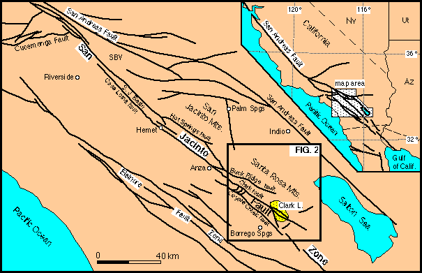
The San Jacinto fault zone (Fig. 1) is a complex zone of splaying and overlapping strike-slip fault segments, steps and bends, and associated zones of contractional and extensional deformation (e.g. Sharp, 1967, 1975; Dibblee, 1984; Sanders, 1989). It belongs to a wide zone of ongoing crustal deformation that makes up the active Pacific-North America plate boundary and includes the southern San Andreas fault to the east, the Elsinore fault to the west, and poorly understood offshore faults farther west (Fig. 1). Offsets on basement piercing points and Pleistocene strata indicate that about 25 km of slip has accumulated on the San Jacinto fault during the past 1.5 to 2.0 Ma (Sharp, 1967; Morton and Matti, 1993; Matti and Morton, 1993). Based on GPS studies and offsets of dated Quaternary deposits, the rate of slip on the San Jacinto system is generally agreed to be ~10-12 mm/yr (Sharp, 1981; Rockwell et al., 1990; Wesnouski et al., 1991; Bennett et al., 1996; Kendrick et al., 1994). This represents 20-25% of the present-day Pacific-North American relative plate motion calculated from the NUVEL-1A plate motion model (DeMets et al., 1994; DeMets, 1995). Slip on the San Andreas fault south of the Transverse Ranges is ~25 mm/yr (Weldon and Sieh, 1985; Bennett et al., 1996), about twice the rate of the San Jacinto fault zone, yet historic seismicity on the San Jacinto fault zone is considerably greater than that of the San Andreas. This discrepancy probably results from the high degree of geometrical complexity of the San Jacinto fault zone, and the tendency for earthquakes to initiate or terminate at segment boundaries and fault step-overs (Sanders, 1989). Understanding the complexities of fault interactions and transfer of slip between fault segments is thus necessary for better understanding the origins of modern seismicity and earthquake potential.
Figure 1
Major styles of fault interaction in the San Jacinto fault zone include: (1) extension, normal faulting, and subsidence in releasing bends and steps such as the subsurface San Jacinto basin (Park et al., 1995; Lee et al., 1996); (2) contraction, folding, thrusting, and uplift in restraining steps such as the Ocotillo Badlands (Brown et al., 1991); (3) triggering of co-seismic slip on northwest-striking right-lateral faults by slip on northeast-striking left-lateral faults (Hudnut et al., 1989; Petersen et al., 1991; Sanders, 1993); and (4) complex patterns of deformation in diffuse zones of fault termination and horse-tail splays (e.g. southern termination of the Clark fault in the Borrego Badlands; Sharp, 1967; Sanders, 1989). Although northeast-striking faults are widely recognized to be an important component of strain in the San Jacinto system, uncertainty exists about their kinematic behavior and relation to adjacent faults and basins. Sharp (1975) interpreted a zone of northeast-striking faults between the Clark and Coyote Creek faults (Fig. 1) to be a zone of local extension on en-echelon normal faults, accommodating transfer of slip between the 2 faults. But recent studies of historic earthquakes in the same structural block and surrounding areas have shown that rupture on northeast-striking faults occurs by left-lateral displacements, not normal slip (Petersen et al., 1991; Mori, 1993). Despite this new information from seismic analysis, little is known about the geological expression or displacement histories of left-lateral faults.
Pleistocene sediments and sedimentary rock sequences represent a powerful but under-utilized tool for reconstructing basin development and fault kinematics in the San Jacinto fault zone. Early to middle Pleistocene deposits are well exposed in many parts of this belt, from the San Timoteo badlands in the north (Morton and Matti, 1993) to the Superstition Hills in the south (Hudnut and Sieh, 1989). A widespread association of Pleistocene strata containing breccia, conglomerate, sandstone and claystone has been informally named the "Bautista Beds" (Frick, 1921; Sharp, 1967). This unit is known to contain the 760-Ka Bishop ash at several localities including the Coyote badlands north of Borrego Springs (this proposal; Fig. 3). Sharp (1981) used stratigraphic relationships and offset of gravels overlying the Bishop ash to measure a slip rate of 8-12 mm/yr on the San Jacinto fault near the town of Anza, and other workers have dated late Pleistocene to Holocene soils and fluvial deposits to obtain similar slip rates (e.g. Rockwell et al., 1990; Kendrick et al., 1994). Otherwise, however, no previous studies in this region have examined dynamic genetic relationships among early to middle Pleistocene sedimentary deposits and the faults that cut them and coincide with their deposition.
Basin subsidence in the San Jacinto fault zone is most likely to occur in pull-apart basins and transtensional sags that form at releasing bends and stepovers between fault strands (e.g. Burchfiel and Stewart, 1966; Aydin and Nur, 1982; Crowell, 1982; Christie-Blick and Biddle, 1985). Modern basins such as the San Jacinto basin (Fig. 1) and Borrego Valley (Fig. 2) are either known or inferred to form in this manner. Other styles of basin development, such as contractional loading or structural damming of streams by adjacent local uplifts, are also possible but are unlikely to produce areally extensive basins and deposits. Thus, widespread thick belts of exposed Pleistocene stratigraphy probably record basin development in transtensive pull-aparts or sag basins that later are destroyed by fault transfer and modern incision caused by uplift or stream capture (or both). Such inferences can be tested with stratigraphic and structural analysis, and the results can be used to develop kinematic models for Pleistocene to modern faulting and basin development.
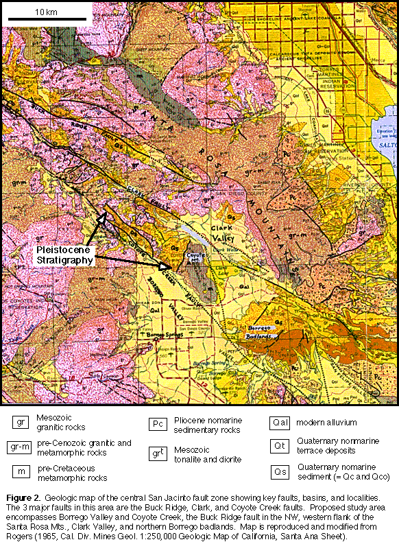
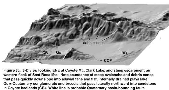
The Coyote Creek - Clark Lake area (Fig. 2, below) was selected for study of Pleistocene to modern faulting, basin development, and landscape evolution because the structural, stratigraphic and geomorphic record of these processes is accessible and well exposed, and numerous outstanding problems remain unresolved. Large, seismically active strike-slip faults in this area include the northwest-striking Coyote Creek, Buck Ridge, and Clark faults which are linked by numerous smaller northeast- and northwest-striking faults. Sharp (1967) used offset of the Santa Rosa mylonite in the study area to estimate 14 km of slip on the Clark fault and 5 km of slip on the Coyote Creek fault. The Buck Ridge fault has produced moderate historical earthquakes, and is shown on existing maps as terminating to the southeast in the southern Santa Rosa Mts. The western flank of the southern Santa Rosa Mts. is a steep topographic escarpment that descends eastward into large debris cones and alluvial fans at the western margin of Clark Lake (Fig. 3). The Clark fault cuts diagonally northwest across Clark Lake. Modern activity on this fault is indicated by fresh fault scarps that cut young sediments and a M 6.2 earthquake that occurred in 1954 on a northwest-striking fault segment near the southeast corner of the lake (Sanders, 1989). The Coyote Creek fault makes up the southwestern boundary of the Coyote badlands and Coyote Mt., and it continues southeastward to Borrego Mt., site of the 1968 M 6.8 earthquake. The largest aftershock of the 1954 event (southeastern Clark Lake) occurred close to the 1968 Borrego Mt. epicenter, which suggests the presence of a structural connection between the Clark and Coyote Creek faults across the Borrego badlands (Sanders, 1989).
|
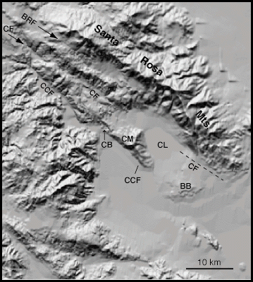
Figure 3a. Shaded relief map of Coyote Creek - Clark Lake area, produced by manipulation of Digital Elevation Model using MicroDEM software package. Figs. 3b and 3c also were produced using MicroDEM. BB = Borrego badlands; BRF = Buck Ridge fault; CB = Coyote badlands; CCF = Coyote Creek fault; CF = Clark fault; CL = Clark Lake; CM = Coyote Mt. |
Pleistocene stratigraphy 100's of m thick is exposed in the Coyote badlands, north of Borrego Valley, where it is juxtaposed against pre-Cretaceous crystalline rocks along a steep NE-trending contact that may be a high-angle fault (Fig. 2, 3). Northwest of that contact there is a systematic lateral fining of alluvial facies toward the northwest, from mega-clast matrix-supported breccia in the southeast, passing through poorly sorted boulder conglomerate, interbedded conglomerate and sandstone, into bedded sandstone facies about 6 km northwest of the probable fault. The sandstone belt is at least 5 km wide, it is cut by young northwest and northeast striking faults including the Coyote Creek fault (Fig. 2, 3), and it contains fresh exposures of the Bishop ash about 8 km northwest of the likely older fault at Coyote Mt. Preliminary paleocurrent data indicate transport of Pleistocene sediments toward the northwest. Pleistocene stratigraphy is now exposed in deeply eroded gullies and canyons up to 400 meters above the floor of the modern fault-controlled Coyote Creek, and Coyote Creek itself flows to the southeast, opposite the direction of Pleistocene paleotransport.
The steep contact at Coyote Mountain probably is a fault that was active during deposition of the Quaternary section, but that needs to be tested. If it is a fault, its northeast trend suggests several possibilities: (1) it formed in its present orientation as a left-lateral strike-slip fault (e.g. Hudnut et al., 1989; Mori, 1993); (2) it formed in its present orientation as a normal fault (e.g. Sharp, 1967, 1975); (3) it formed as a north-striking normal or oblique-normal fault, perhaps accommodating subsidence in a pull-apart basin, which later rotated into its present position. The contrast between Pleistocene paleotransport directions (toward the NW) and modern transport in Coyote Creek (toward the SE) needs to be understood. How did initiation of new faults and/or stream-capture events cause drainage directions to be completely reversed between ~ 700,000 years ago and the present? What is the direction, magnitude, and timing of slip on faults that cut the Pleistocene stratigraphy, and how do they relate to the active Coyote Creek and Clark faults that control modern drainages? These questions are important for understanding the kinematic history of faulting and basin development, and can be resolved through detailed mapping, stratigraphic and structural analysis, geomorphic surveying, image analysis, and paleomagnetic studies.
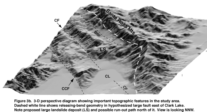
The precipitous escarpment on the east side of Clark Valley, abundance of steep coarse breccias and alluvial fans that pass laterally over a short distance into playa lake deposits, and the internally drained hydrology of the lake, all suggest that the eastern margin of the valley is controlled by a large, active normal or oblique-normal fault, and that Clark Lake is a pull-apart basin formed in a releasing stepover between the Clark and Buck Ridge strike-slip faults (Figs. 2, 3). However, the freshest modern fault scarps apparently are not on the eastern margin of the valley, but instead follow several traces of the Clark fault that cut diagonally northwest across the basin floor (Sharp, R.V., and Rockwell, T., personal comm. 1997). Other observations reveal that the northern margin of Clark Lake is bounded by hummocky high topography underlain by Cretaceous granite (Figs. 2, 3). Existing maps (Fig. 2) show the Buck Ridge fault terminating to the southeast in the Santa Rosa Mountains, and thus slip apparently is not balanced. The western end of hummocky Cretaceous granite is cut by the active Clark fault. Sharp (1967)estimated that this pluton was displaced ~12 km to the northwest on the southwest side of the Clark fault.
Basic uncertainty exists regarding the origin of Clark Lake. Leading questions to be addressed include: (1) What are the directions, timing, and rates of recent slip on fault scarps (if present) in the steep eastern escarpment and on the Clark fault in the basin center? (2) Is the Clark fault the only active structure in the modern valley, and if so, does the steep eastern escarpment represent an older, now-abandoned basin-margin fault? If true, is Clark Lake a pull-apart basin in the process of becoming extinct, in a manner similar to that observed in the Haiyuan fault zone of China (Zhang et al., 1989)? (3) Cretaceous granite exposed in hummocky topography at the north end of Clark Lake appears to be the deposit of a large-volume rock avalanche derived from crystalline basement sources to the northwest (Fig. 3b). A high valley northwest of the hummocky terrain appears to be a likely transport path for avalanche debris, and a gap in an otherwise continuous trend of granite on the northeast margin of the upper valley further supports this hypothesis. The rock-avalanche hypothesis needs to be tested, and implications of either result need to be explored. If it is a large landslide, what is its age, how far did it travel, how many events are represented, and what are the geometry and ages of structures that bound the basin into which it flowed? If it's not a rock avalanche, what is the nature of the northern margin of the Clark Lake, are any faults present, and what is their age?
(1) What are the structural linkages between the Coyote Creek and Clark faults, how do they control basin formation, and how has slip been transferred between them from Pleistocene to the present?
(2) How do temporal changes in fault slip control changes in topography through time, and how are these changes reflected in the stratigraphic and geomorphic record?
(3) What fault kinematics cause basins to be uplifted while previously positive areas subside? Can we distinguish between real vertical displacements and lateral juxtaposition of topography?
(4) What is the geomorphic record of basin exhumation in the San Jacinto fault zone? If dateable surfaces are present, what do they tell us about the timing and rates of exhumation?
(5) Is Clark Lake a pull-apart basin, and if so, is it in the early stages of being destroyed?
(6) How do dilational and contractional fault steps and NE-striking left-lateral faults influence the formation of topography and basins in this area? How do those controls change through time?
(7) Is the San Jacinto fault zone in this area tending to become more simple through time, or is the structural complexity a fundamental, long-lasting aspect of its behavior?
These questions will be addressed by comparing: age and facies patterns in older stratigraphy, kinematic data from Pleistocene faults, raised alluvial surfaces, modern depositional systems, and active structures. The Coyote Creek - Clark Lake area is ideally suited for this kind of integrative study which will utilize a variety of field and computer-aided techniques, described here.
In the aftermath of this project, analysis of the high valley and bounding faults north of Clark Lake will be pursued. Future work may also take us south of the present study area into the Borrego badlands. Finally, a thick deformed package of Miocene to Pleistocene strata on the southern and eastern flanks of the Santa Rosa Mountains (Fig. 2) is important for understanding the tectonic evolution of this area, and yet remains very poorly understood. These older strata and their defining structures will be a target for future funded research to address questions about interactions between Miocene detachment faulting and younger strike-slip deformation and basins in the region.
Return to Dorsey's Homepage